DesertWeather.com logo

DesertWeather.com

Live weather information for the Coachella Valley
Thousand Palms, California

Thousand Palms, California
75
°F
Colder 2.9°F than last hour.
Mild — clear
Feels like 77.2°F  ·  This time yesterday: 76°F
Past 2 Hours ▼ -7.4°F
74.9° 82.3°
2hr ago 60m Now
85
Today’s High
1:55 PM
89°
Yesterday’s High
1:34 PM
57
Today’s Low
6:09 AM
58°
Yesterday’s Low
6:19 AM
Updated: 5:50:00 pm PST
Humidity
34 %
24h diff 3%
Hi 52% 6:12 AM
Lo 23% 11:45 AM
Dew Point
45 °F
24h diff 2°F
Hi 51° 9:28 AM
Lo 38° 3:23 AM
Wind
ENE2 mph
Gust 1.0 mph
Top gust 14.0 mph (12:46 PM)
Cloud Height / Wind
7204 ft
10m avg 2.3 mph
Hour top gust 5 mph ENE
Wind Run  mi
Barometer
29.75 in
Steady  ·  24h diff -0.18
Hi 29.93 12:00 AM
Lo 29.74 4:36 PM
Solar
0 wm
0% of max
Daylight 10:28 hr
High Solar 647 wm
Max Temp for this Date
94 °F
2021 · (This Station · Since 2004)
Min Temp for this Date
42 °F
2012 · (This Station · Since 2004)
This time yesterday
76 °F
-0.9° vs now
Record high (this date)
95 °F
1933 · (Palm Springs Airport)
Rain today
0.00 in
Rate: 0.000 in/hr
Yesterday
0.00  in
Storm: 0.00 in
November
0.01 in
Last rain: 11/1/2026
Cal year
2.58 in
11 days since rain
Water year
1.54 in
Oct.’25 – Sep.’26
Max rain rate: 0.000 (00:00 AM)
CWOP: CW2285  ·  WU: KCATHOUS8
NWS verified rain gauge
4 UV  ·  Moderate  ·  Nov 12
Live data from sensors installed in Thousand Palms, CA  ·  Rain verified by NWS Standard Rain Gauge
GRAPHS, LAST 3 HOURS — click to expand
Temperature °F74.8
▼ Last hour: -3.1 °F
74.8°84.2°
3hr ago90mNow
Dew Point °F5m avg45.0
▼ Last hour: -0.8 °F
44.4°46.0°
3hr ago90mNow
Avg Wind Speed mph10m avg2.0
▲ Last hour: +0.9 mph
0.06.1
3hr ago90mNow
Wind Gust mph4.0
▲ Last hour: +3.0 mph
0.09.0
3hr ago90mNow
Humidity %5m avg34
▲ Last hour: +2 %
2634
3hr ago90mNow
Barometer inHg5m avg29.75
● Last hour: +0.00 inHg
29.7429.77
3hr ago90mNow
Solar W/m²0
▼ Last hour: -5 W/m²
088
2hr ago60mNow
Rain in0.00
● Last hour: +0.00 in
3hr ago90mNow


warnings updated: Thursday, November 12, 2026, 5:48 pm PST


NWS San Diego Forecast Discussion – Synopsis
Issued 1235 PM PST Thu Nov 12 2026

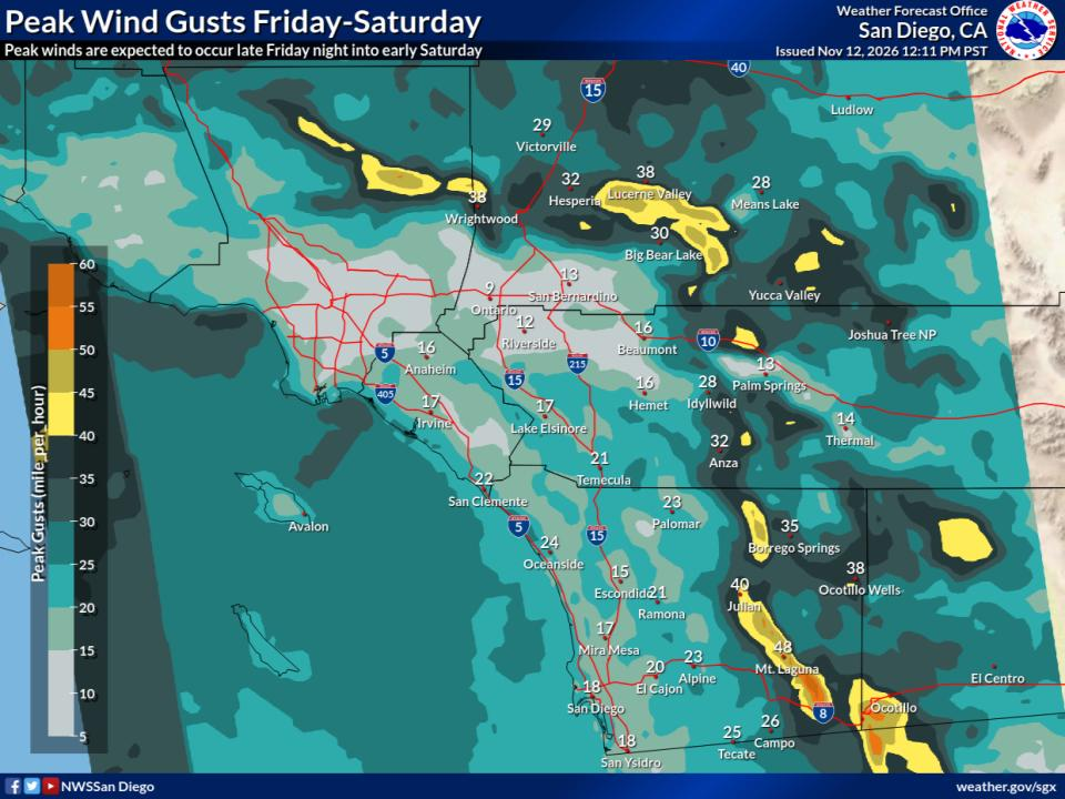
Cooler conditions with increased cloud coverage is expected through early next week. Periods of rain are expected Friday through next week. The first round is expected Friday morning, with chances of isolated thunderstorms over the coastal waters locally into the beaches. The next chance will be Friday evening into Saturday, with more widespread light to locally moderate showers. In addition to periods of rain, winds are expected to increase over the mountains, deserts, and coastal waters. Sunday could see mostly dry conditions with our next chances of precipitation and increased winds Monday through Wednesday.

Covers extreme southwestern California, including Orange, San Diego, western Riverside and southwestern San Bernardino counties.
Read the full forecast discussion


WEATHER STORY
San Diego
Weather Forecast Office
Highs Friday Highs Saturday Rain Fri AM Rain Fri PM to Sat PM Weekend Winds
Open WFO in new window/tab

Gusty south and west winds this weekend, especially Friday evening through Saturday morning. During this time, gusts 25-45 mph over the mountains and deserts, and gusts 45-55 mph through the passes. Over the waters, expect gusts up to 25 knots. Winds decrease late Saturday through early Monday, then increase again late Monday into Tuesday to likely similar levels. These winds, in combination with a large northwest swell, will bring choppy, steep seas to the region for much of the weekend into parts of next week.

Data Courtesy of San Diego Weather Forecast Office


Hyperlocal Radar not Active at this time


Hourly Forecast for Select Locations

Forecast Source: National Weather Service

Forecast generated: Thu Nov 12, 11:13 AM PST     Last checked: Thu Nov 12, 12:00 PM PST
Temperature, °F
Temperature, °F chart.
Sky cover, %
Sky cover, % chart.
Probability of precipitation, %
Probability of precipitation, % chart.
Precip. amount, in
Precipitation, in Total accumulation, in
Precip. amount, in chart.
Wind speed / gust, mph
Wind speed / gust, mph chart.


Record Watch

Data: NWS - Palm Springs (KPSP)


Rain Climatology

Rainfall data: Thousand Palms, CA(DesertWeather.com) / Climate data: DesertWeather.com - Averaged data, last 25 years. Archived gauges displayed HERE.

November 1-12

Observed Rainfall: 0.01 in.
Normal Rain for November 1-12: 0.02 in.

Departure from Normal: below  -0.01 in.
Jan 1 to November 12, 2026

Observed Rainfall: 2.58 in.
Normal Rain for Jan 1 to Nov 12, 2026: 2.75 in.

Departure from Normal: below  -0.17 in.
Water Year: Oct 2025 to Sep 2026

Observed Rainfall: 1.54 in.
Normal Rain for Oct 1 to Nov 12, 2026: 0.28 in.

Departure from Normal: above  1.26 in.


Webcam image TP1 Webcam image TP2 Webcam image RM


Weathercams - Sunset Gallery - Click Here


Almanac

Almanac information is for the Palm Springs Airport and is provided by the National Weather Service.

High 80° normal 95° record (1933)
Low 55° normal 34° record (1950)
Sunrise 6:16am
Sunset 4:45pm
Moonrise 9:34am
Moonset 7:10pm
Moon phase
Illumination 10%
Fire danger gauge
Sun and moon position chart


Evaporative Cooler Effectiveness by City


Thousand Palms
POOR IDEAL Evap Cooler Effectiveness Fair Score 56/100 · 17°F wet-bulb depression
Outside Temp 75°F
Dew Point 45°F
Est. Output 61°F
Updated: Nov 12, 5:53 PM PST
It's already a comfortable 75°F outside — running the cooler isn't needed.
Palm Desert (Hwy 111 & El Paseo)
POOR IDEAL Evap Cooler Effectiveness Fair Score 50/100 · 15°F wet-bulb depression
Outside Temp 75°F
Dew Point 49°F
Est. Output 63°F
Updated: Nov 12, 5:44 PM PST
It's already a comfortable 75°F outside — running the cooler isn't needed.
Palm Springs Airport
POOR IDEAL Evap Cooler Effectiveness Good Score 66/100 · 20°F wet-bulb depression
Outside Temp 78°F
Dew Point 42°F
Est. Output 62°F
Updated: Nov 12, 4:53 PM PST
Thermal Airport
POOR IDEAL Evap Cooler Effectiveness Fair Score 51/100 · 15°F wet-bulb depression
Outside Temp 73°F
Dew Point 46°F
Est. Output 61°F
Updated: Nov 12, 4:52 PM PST
It's already a comfortable 73°F outside — running the cooler isn't needed.

How to Read This

Score

0–100, based on the wet-bulb depression — how much cooler the air could get versus the actual outside temperature. Drier air means more room to cool, so a bigger gap scores higher.

Wet-Bulb Depression

The gap between the outside (dry-bulb) temperature and the wet-bulb temperature — the coolest evaporation alone could get the air. A bigger gap means drier air and more room for the cooler to work with.

Estimated(Est.) Output

The approximate temperature of the air coming out of the cooler, estimated by cooling the outside temperature most of the way toward the wet-bulb temperature.

Efficiency

These numbers assume 80% saturation efficiency — typical for a well-maintained direct (single-stage) evaporative cooler.

Lower dew point + higher temp = better cooling


(This guide generally will work for misting systems also)


DesertWeather.com