DesertWeather.com logo

DesertWeather.com

Live weather information for the Coachella Valley
Thousand Palms, California

Desert Weather Guesser - guess the weather, win bragging rights. Play free.
Thousand Palms, California
99
°F
Warmer 2.2°F than last hour.
Warm — clear
Feels like 95.0°F  ·  This time yesterday: 101°F
Past 2 Hours ▲ +2.9°F
96.3° 99.2°
2hr ago 60m Now
99
Today’s High
4:22 PM
103°
Yesterday’s High
3:31 PM
76
Today’s Low
7:10 AM
75°
Yesterday’s Low
4:43 AM
Updated: 4:23:00 pm PDT
Humidity
16 %
24h diff 3%
Hi 41% 12:00 AM
Lo 15% 4:18 PM
Dew Point
45 °F
24h diff 4°F
Hi 56° 12:38 AM
Lo 43° 4:19 PM
Wind
SE4 mph
Gust 3.0 mph
Top gust 23.0 mph (3:26 AM)
Cloud Height / Wind
12654 ft
10m avg 4.5 mph
Hour top gust 10 mph SW
Wind Run  mi
Barometer
29.70 in
Steady  ·  24h diff -0.01
Hi 29.81 10:04 AM
Lo 29.7 4:14 PM
Solar
503 wm
100% of max
Daylight 12:14 hr
High Solar 932 wm
Max Temp for this Date
109 °F
2012 · (This Station · Since 2004)
Min Temp for this Date
64 °F
2007 · (This Station · Since 2004)
This time yesterday
101 °F
-1.9° vs now
Record high (this date)
113 °F
1975 · (Palm Springs Airport)
Rain today
0.00 in
Rate: 0.000 in/hr
Yesterday
0.00  in
Storm: 0.00 in
September
0.07 in
Last rain: 9/6/2026
Cal year
1.05 in
13 days since rain
Water year
2.96 in
Oct.’25 – Sep.’26
Max rain rate: 0.000 (00:00 AM)
CWOP: CW2285  ·  WU: KCATHOUS8
NWS verified rain gauge
8.2 UV  ·  Very High  ·  Sep 20
Live data from sensors installed in Thousand Palms, CA  ·  Rain verified by NWS Standard Rain Gauge

GRAPHS, LAST 3 HOURS:

Temperature °F98.6
▲ Last hour: +1.3 °F
95.4°99.0°
3hr ago90mNow
Dew Point °F5m avg45.0
▼ Last hour: -2.8 °F
44.6°52.0°
3hr ago90mNow
Avg Wind Speed mph10m avg4.1
▲ Last hour: +1.2 mph
0.07.8
3hr ago90mNow
Wind Gust mph7.0
▲ Last hour: +1.0 mph
0.012.0
3hr ago90mNow
Humidity %5m avg16
▼ Last hour: -3 %
1623
3hr ago90mNow
Barometer inHg5m avg29.70
▼ Last hour: -0.02 inHg
29.7029.77
3hr ago90mNow
Solar W/m²503
▲ Last hour: +113 W/m²
207773
2hr ago60mNow
Rain in0.00
● Last hour: +0.00 in
3hr ago90mNow


warnings updated: Sunday, September 20, 2026, 4:18 pm PDT


Hyperlocal Radar not Active at this time


Summer Moisture / Monsoon Watch. Hourly Forecast for Select Locations

Forecast Source: National Weather Service

Forecast generated: Sun Sep 20, 11:32 AM PDT     Last checked: Sun Sep 20, 12:00 PM PDT
Temperature, °F
Temperature, °F chart.
Dew point, °F
Dew point, °F chart.


Record Watch

Data: NWS - Palm Springs (KPSP)


Rain Climatology

Rainfall data: Thousand Palms, CA(DesertWeather.com) / Climate data: DesertWeather.com - Averaged data, last 25 years. Archived gauges displayed HERE.

September 1-20

Observed Rainfall: 0.07 in.
Normal Rain for September 1-20: 0.23 in.

Departure from Normal: below  -0.16 in.
Jan 1 to September 20, 2026

Observed Rainfall: 1.05 in.
Normal Rain for Jan 1 to Sep 20, 2026: 2.46 in.

Departure from Normal: below  -1.41 in.
Water Year: Oct 2025 to Sep 2026

Observed Rainfall: 2.96 in.
Normal Rain for Oct 1 to Sep 20, 2026: 3.66 in.

Departure from Normal: below  -0.70 in.


Webcam image TP1 Webcam image TP2 Webcam image RM


Weathercams - Sunset Gallery - Click Here


Almanac

Almanac information is for the Palm Springs Airport and is provided by the National Weather Service.

High 100° normal 113° record (1975)
Low 73° normal 50° record (1965)
Sunrise 6:34am
Sunset 6:47pm
Moonrise 3:32pm
Moonset 12:29am
Moon phase
Illumination 67%
Fire danger gauge
Sun and moon position chart


WEATHER STORY
San Diego
Weather Forecast Office
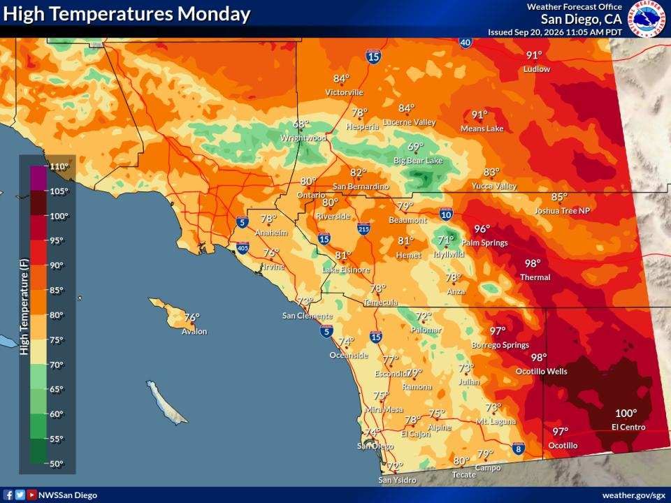
Highs Today Highs Monday Highs Tuesday Highs Thursday
Open WFO in new window/tab

Map of forecast high temperatures for Southern California for Monday Sep 21, 2026. For the coastal areas: 72 to 76, western valleys and inland Orange County: 75 to 80, inland valleys: 75 to 82, mountains between 4000 ft and 7000 ft: 67 to 80, high desert: 82 to 90, low desert: 95 to 100.

Data Courtesy of San Diego Weather Forecast Office


Evaporative Cooler Effectiveness


POOR IDEAL Evap Cooler Effectiveness Excellent Score 100/100 · 32°F wet-bulb depression
Outside Temp 99°F
Dew Point 45°F
Est. Output 73°F

How to Read This

Score

0–100, based on the wet-bulb depression — how much cooler the air could get versus the actual outside temperature. Drier air means more room to cool, so a bigger gap scores higher.

Estimated(Est.) Output

The approximate temperature of the air coming out of the cooler, estimated by cooling the outside temperature most of the way toward the wet-bulb temperature.

Efficiency

These numbers assume 80% saturation efficiency — typical for a well-maintained direct (single-stage) evaporative cooler.

Lower dew point + higher temp = better cooling


(This guide generally will work for misting systems also)


DesertWeather.com